


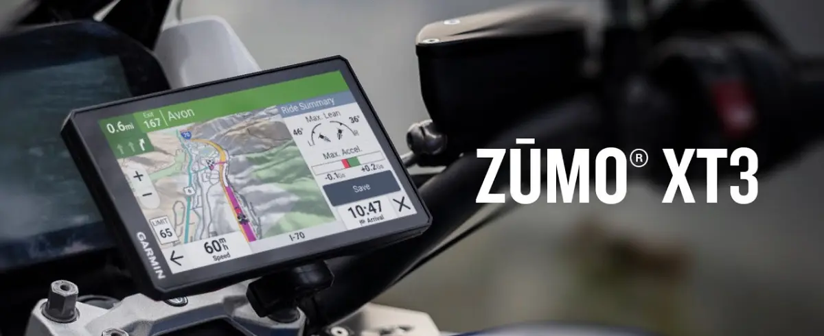
Garmin Zumo XT3: Navigate every twist and turn with a device built for your passion for adventure!

Built To Withstand Weather And Vibration

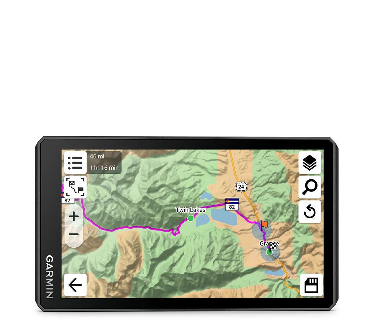
Ride With Detailed Street, Topographic Maps And Satellite Imagery

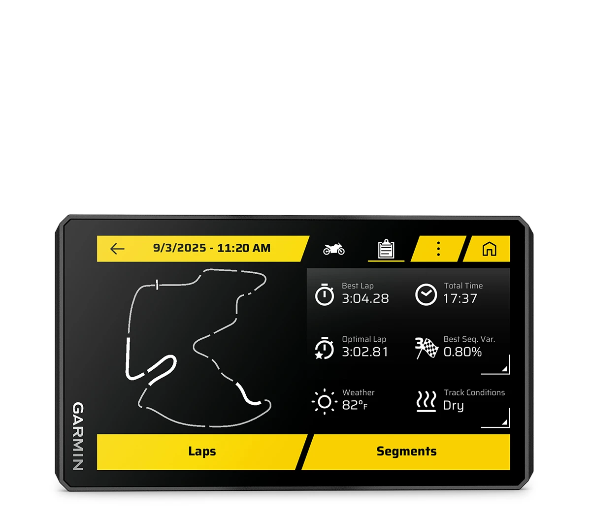
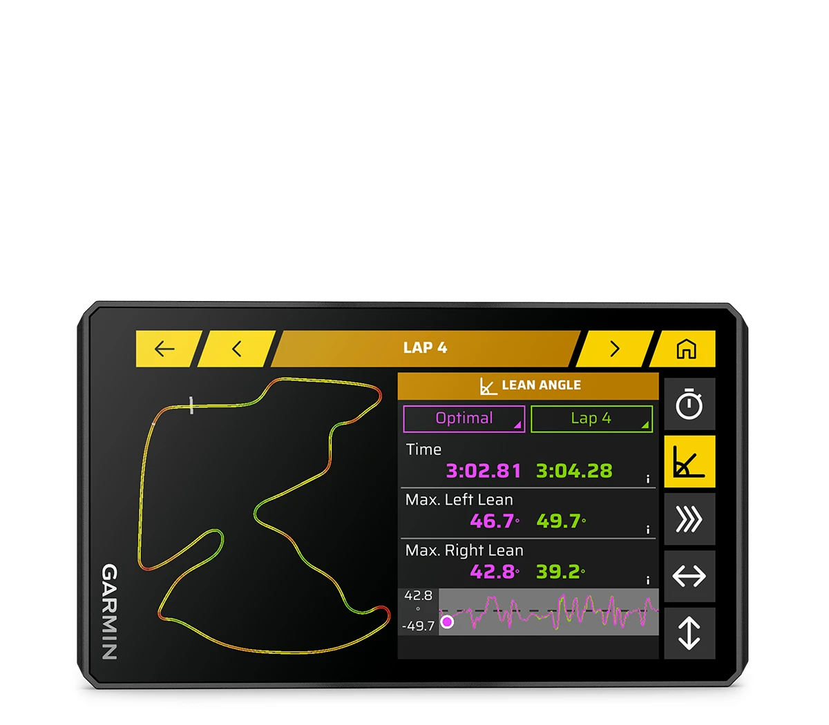
See Your Lean Angle, G-Force, Max Speed And More

Create A Custom Route With The Tread Mobile App

Find The Twists And Turns With The Garmin Adventurous Routing Setting

Activate A Plan For Garmin Performance Package Drag Racing Features
Hit the road with the Garmin zūmo XT3, a motorcycle navigator built for riders who’d rather take the long way every time. The glove-friendly, ultrabright 6″ display stays clear in sun, rain, and whatever else the ride throws at it. It has a rugged, vibration-resistant build made for life on the bars. From twisty backroads to cross-country routes, the XT3 keeps you dialed with detailed street maps, topo data, and vivid satellite imagery so you always know what’s ahead and what’s worth turning toward.
This thing is made for how riders actually ride. Garmin Adventurous Routing helps you skip the boring roads and find the good stuff with more curves, elevation, and scenery, plus selectable difficulty levels. Rider alerts call out sharp curves and changes along your route. Pair the zūmo R1 Radar (sold separately) and you get blind-spot awareness right on your screen. Add the handlebar controller (sold separately) for easy map control without lifting a hand. Track recorder logs your ride stats like speed, distance, and lean angle. Everything syncs cleanly through the Tread app.
XT3 keeps the connected stuff simple too. Built-in Wi-Fi updates maps and software without a computer. The Tread app brings in traffic, weather, routes, and notifications. Riding beyond coverage? Pair a compatible inReach® satellite communicator (sold separately) for messaging, location sharing, and SOS backup. Whether it’s a day ride or a multi-state run, the zūmo XT3 is built to make every mile better.
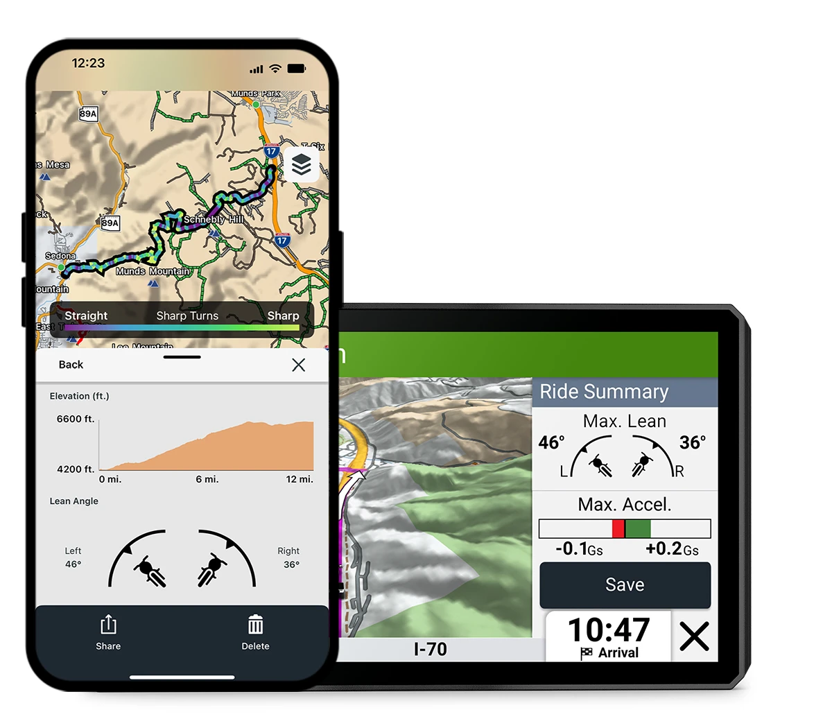
Lean Angles
View and share lean angle, G-force, max speed, and more in your ride summary through the Tread® smartphone app.
Group Tracking
Use the Tread app on your smartphone and/or your zūmo XT3 device to track friends with the group ride mobile feature1 when cell coverage is available. For rides beyond cell coverage, use the Group Ride Radio accessory with the Group Ride Radio Y-adapter (each sold separately) to track other riders using compatible zūmo or Tread navigators.
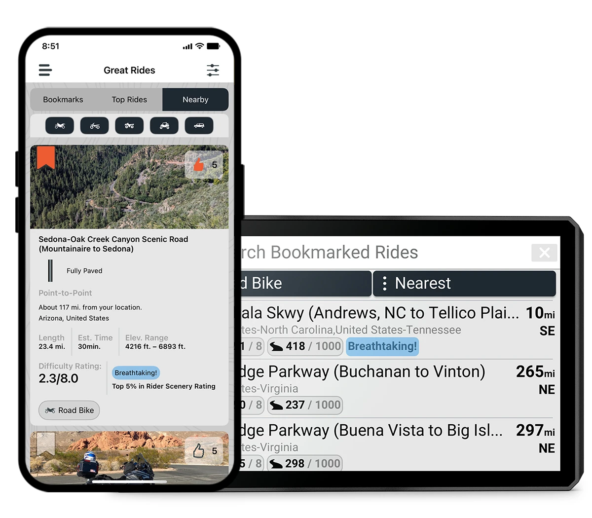
Find New Routes
Discover new rides with the great rides feature in the Tread smartphone app. Bookmark routes to sync them automatically to your device, then add difficulty ratings and upload photos to share with other riders.
Visual Route Planner
Plan a custom route on the device, or use the Tread app with a compatible smartphone. Select custom routing features such as curves, hills or scenic byways. You can also import your own route via GPX, KML or KMZ files.
Drag Race Timer
Record your 0–60 mph time and your 1/8-mile and 1/4-mile times with an active Garmin Performance Package.
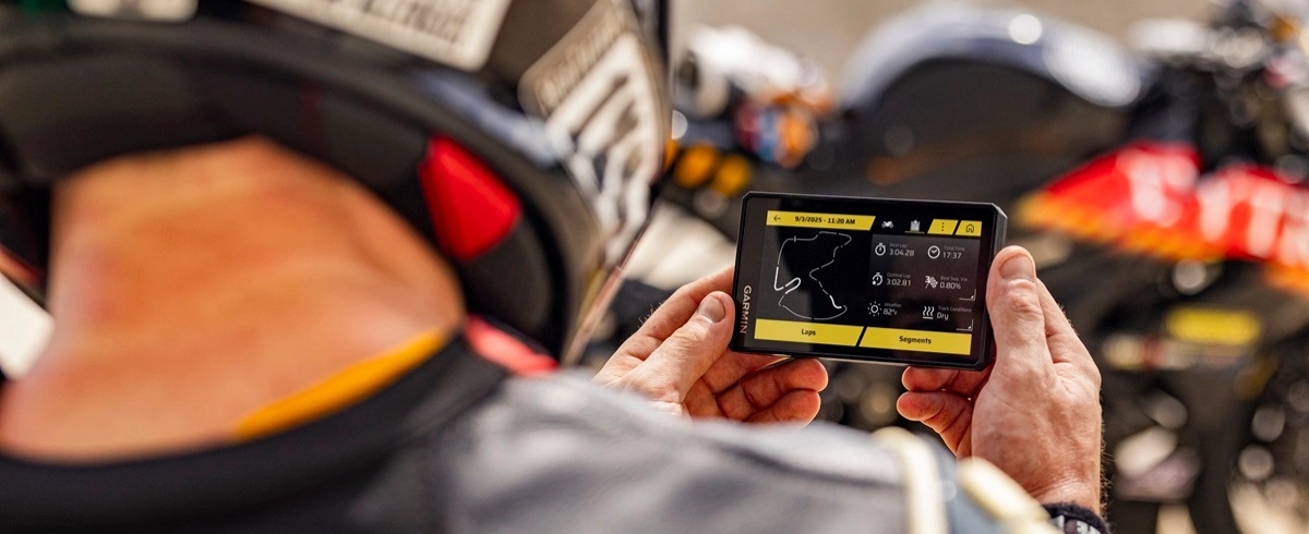
Lap Time Review
See your lap times, race metrics, delta times and lean angles through each turn and more with an active Garmin Performance Package.
Ready To Ride

Popular Paths
Discover popular motorcycle routes ridden by other riders and uncover new, exciting roads to explore.

Garmin Adventurous Routing
Straight roads are boring. Let Garmin Adventurous Routing find thrilling rides with hills, curves, and scenic stretches — with 4 selectable difficulty levels.

Satellite Imagery
High-resolution satellite imagery delivers vivid overhead views of your route and surrounding terrain for confident navigation. Download maps directly to your device via Wi-Fi — no subscription required.

Music And Directions
Keep your headset paired to your phone to control music and hear turn-by-turn directions from your navigator. Voice prompts are delivered to your headset through your phone.

Traffic and Weather
View real-time traffic and weather, share routes with fellow riders, and receive smartphone notifications through the Tread app.
Seek Adventure

Outdoor Maps+
With an active Outdoor Maps+ plan, access a wide range of premium mapping content, including Adventure Roads and Trails for turn-by-turn routing when riding off-road. Content is regularly updated and delivered directly to your device.

Track Recorder
Record ride data such as speed, distance, lean angle, acceleration, and more — then share your ride details with friends in the Tread app.

Manage Your Data
Easily manage tracks and routes across your navigator and compatible smartphone using the Tread app.

Rider Alerts
Receive alerts for hazards along your route, including sharp curves, speed changes, and more. You’ll also get notifications about state helmet laws.

Incident Notifications
If an incident is detected, a text message with location details is automatically sent to your designated contact.
More For Moto

Blind-Spot Monitoring
Pair your navigator with the zūmo™ R1 Radar system (sold separately) for rear-view and blind-spot monitoring. Integrated lights help increase your visibility to other drivers, and nearby vehicles can be displayed directly on your navigator screen.

Handlebar Controller
Control your map more conveniently while keeping your hands on the handlebars when paired with the wired handlebar controller accessory (sold separately).

Off-Grid Communication
When riding beyond cellular coverage, pair with a compatible inReach satellite communicator⁴ (sold separately) for two-way messaging, location sharing, and SOS emergency activation.

Free Ride
Explore freely with simple compass navigation that shows direction and distance to your destination.

Wireless Updates
Built-in Wi-Fi connectivity lets you easily keep maps and software up to date without a computer. On-screen prompts notify you when updates are available.
Availability
*** In stock and shipping FREE from Texas now! *** Order today!
Frequently Asked Questions - Garmin zūmo XT3 Navigator
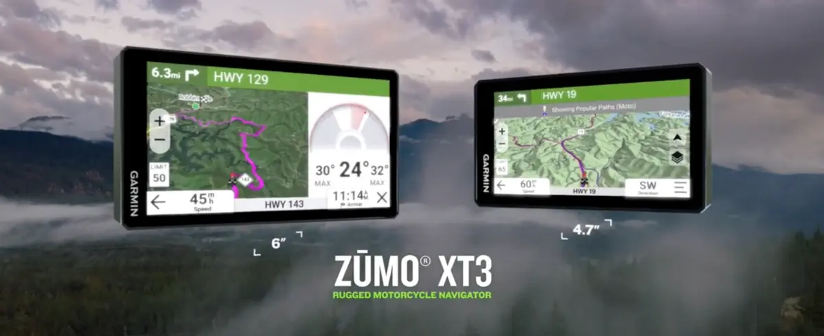
The zūmo XT3 lineup shares the same rugged build, advanced routing features, and performance capabilities across both models. Whether you choose the 4.7" or the 6" version, you're getting the same navigation platform, maps, sensors, group ride features, and motorcycle-specific tools.
The main differences between the two models come down to mounting hardware and the type of bike they’re best suited for. The XT3 4.7" is geared more toward smaller bikes, sport bikes, and naked bikes where cockpit space is tighter, and it typically uses a post-mount setup better suited for compact mounting positions.
The XT3 6" is a better fit for touring and adventure bikes with more room available, and it comes with a standard handlebar mount kit with U-bolt base, along with handlebar controls.
| Accessories Included with XT3 4" |
Motorcycle post-mount and hardware Motorcycle power cable Charging/data cable Documentation |
| Accessories Included with XT3 6" |
Motorcycle handlebar mount kit Motorcycle power cable Charging/data cable Documentation |
| Dimension |
4.7": 5.04" W x 2.95" H x 0.95" D (12.8 x 7.5 x 2.4 cm) 6": 6.15" W x 3.5" H x 1" D (15.6 x 8.9 x 2.5 cm) |
| Weight |
4.7": 7 oz (190 g) 6": 12 oz (340 g) |
| Waterproof | IPX7 |
| Dust Rating | IP6X |
| Display Type | multi-touch, glass, high brightness HD color TFT with white backlight |
| Display Size |
4.7": 4.0" W x 2.3" H (10.3 x 5.8 cm); 4.66" diag (11.8cm) 6": 5.3" W x 3.0" H (13.3 x 7.5 cm); 6" diag (15.3cm) |
| Screen Resolution | 1280 x 720 pixels |
| Dual-Orientation Display | ✔ |
| Handlebar Mount (Up To 1") | see Additional |
| Post Mount | 4.7": yes, M8 mounting bolts (55 mm, 60 mm, 65 mm lengths) |
| Drop Rating | MIL-STD-810 |
| Battery Type | Rechargeable lithium-ion |
| Battery Life | up to 7 hours (up to 5 hours at 100% backlight) |
| Data Cards | microSD™ card (not included) |
| Preloaded Street Maps | ✔ |
| High Definition 3D Terrain | ✔ |
| 3D Terrain | ✔ |
| Internal Storage | 64GB |
| Ability To Add Maps | ✔ |
| External Memory Storage | yes (256 GB max microSD™ card) |
| Includes Map Updates | ✔ |
| Downloadable Satellite Imagery | ✔ |
| TOPO Map Support | ✔ |
| GPS | ✔ |
| Galileo | ✔ |
| 25 Hz Multi-GNSS Positioning | ✔ |
| Point-To-Point Navigation | ✔ |
| Preloaded Topographic Maps | ✔ |
| Navigate-A-Track Navigation | ✔ |
| Compatible With Outdoor Maps+ Subscription | ✔ |
| Backup Camera Compatible | yes (BC™ 50) |
| Visual Route Planner | ✔ |
| Garmin Real Directions Landmark Guidance | ✔ |
| TripAdvisor Traveler Ratings | ✔ |
| Route Shaping through Preferred Cities/streets | ✔ |
| Includes Traffic | yes (with Garmin Tread app) |
| Lane Assist with Junction View (displays Junction Signs) | ✔ |
| Bluetooth Pairing | yes (works with Bluetooth-compatible helmet, headset or smartphone. BLE capable.) |
| Speed Limit Indicator | ✔ |
| Driver Alerts for Sharp Curves, School Zones, Red Light and Speed Camera Warnings and More | ✔ |
| Glove-Friendly Touchscreen | ✔ |
| Control Music And Media From Smartphone Or Mp3 Player | ✔ |
| Sunlight Readable And Weather Resistant | ✔ |
| Garmin Adventurous Routing | ✔ |
| Lean Angles | ✔ |
| Rider Alert Warnings For Sharp Curves, State Helmet Laws, Speed Cameras And More | ✔ |
| Planned & Dynamic Fuel Stops | ✔ |
| Helmet Law Notifications | ✔ |
| Popular Paths (Moto) | ✔ |
| Elevation Profile | ✔ |
| Round Trip Routing | ✔ |
| Track Support | ✔ |
| Custom Map Support | ✔ |
| Wireless Ant+® Technology | ✔ |
| Smart Notifications Via App | ✔ |
| Wi-Fi® Map And Software Updates | ✔ |
| Access To Live Services Via App (Traffic, Weather, Etc.) | ✔ |
| Pair With Compatible InReach® Devices | ✔ |
| Pair With Garmin Powerswitch™ Digital Switch Box | ✔ |
| Compatible With Handlebar Controller | ✔ |
| Compatible With Group Ride Radio | ✔ |
| Group Ride Mobile | ✔ |
| Track Recorder (Breadcrumbs) | ✔ |
| Compatible With The Garmin Tread App For Route Planning And Data Management | ✔ |
| Ultimate Public Campgrounds | ✔ |
| Glove-Friendly Touchscreen | ✔ |
| Built-In Accelerometers | yes (with Performance Package) |
| Displays Best Lap Time, Adaptive Delta Time, Number Of Laps And Total Session Time | yes (with Performance Package) |
| Preloaded Global Track Database | yes (with Performance Package) |
| Session Comparisons | yes (with Performance Package) |
| Supports Multiple Cars | yes (with Performance Package) |
| Stores History Of All On-Track Performance | yes (with Performance Package) |
| Current Weather Plus 5 Day Forecast Via Wi-Fi | yes (with Performance Package) |
| Segment Analysis (Racing Line, Speed And Acceleration/Deceleration) | yes (with Performance Package) |
| Leaderboards | yes (with Performance Package) |
| Friend Comparisons | yes (with Performance Package) |
| Handlebar Mount (Up To 1") | 6" only |
Videos Hide Videos Show Videos
-

Enjoy the Ride of Your Life with zumo XT3 | Garmin
Learn more: https://garmin.com/en-US/p/1904331 Nothing matche...
-
zūmo® XT3 | The Life of Your Ride
Nothing matches the thrill of riding a motorcycle. From the r...
-
zumo XT3 (4.7") | Getting Started | Garmin Support
Learn the layout and how to complete the basic setup of your n...


Garmin
Garmin Parking Mode Kit | USB-C Direct-Wire Power Cable
Looking to "hard-wire" your USB-C Garmin dash cam to your vehicle's electrical system? Garmin's direct-wire power cable harness is exactly what you need to safely enable parking mode on your......

Garmin
Garmin Dual Outlet USB Power Adapter & USB-C Cables
Power your compatible Garmin Dash Cam with this adapter while also having the ability to charge a phone, tablet or other device that needs power while on the go. Includes one long 13 ft (4 meter)......

Garmin
Garmin Extra-Long USB-C Power Cable
Power and recharge your compatible Garmin Dash Cam (or other compatible USB-C device) with this extra-long 26ft (~8 meter) power cable. Has a right-angle USB-C plug on the camera end, which is......

Garmin
Garmin BC50 Wireless Backup Camera
*** Garmin BC50 | Now available! *** Garmin BC50 | Reverse With Confidence ...
Frequently Asked Questions - Garmin zūmo XT3 Navigator
The zūmo XT3 lineup shares the same rugged build, advanced routing features, and performance capabilities across both models. Whether you choose the 4.7" or the 6" version, you're getting the same navigation platform, maps, sensors, group ride features, and motorcycle-specific tools.
The main differences between the two models come down to mounting hardware and the type of bike they’re best suited for. The XT3 4.7" is geared more toward smaller bikes, sport bikes, and naked bikes where cockpit space is tighter, and it typically uses a post-mount setup better suited for compact mounting positions.
The XT3 6" is a better fit for touring and adventure bikes with more room available, and it comes with a standard handlebar mount kit with U-bolt base, along with handlebar controls.
| Accessories Included with XT3 4" |
Motorcycle post-mount and hardware Motorcycle power cable Charging/data cable Documentation |
| Accessories Included with XT3 6" |
Motorcycle handlebar mount kit Motorcycle power cable Charging/data cable Documentation |
| Dimension |
4.7": 5.04" W x 2.95" H x 0.95" D (12.8 x 7.5 x 2.4 cm) 6": 6.15" W x 3.5" H x 1" D (15.6 x 8.9 x 2.5 cm) |
| Weight |
4.7": 7 oz (190 g) 6": 12 oz (340 g) |
| Waterproof | IPX7 |
| Dust Rating | IP6X |
| Display Type | multi-touch, glass, high brightness HD color TFT with white backlight |
| Display Size |
4.7": 4.0" W x 2.3" H (10.3 x 5.8 cm); 4.66" diag (11.8cm) 6": 5.3" W x 3.0" H (13.3 x 7.5 cm); 6" diag (15.3cm) |
| Screen Resolution | 1280 x 720 pixels |
| Dual-Orientation Display | ✔ |
| Handlebar Mount (Up To 1") | see Additional |
| Post Mount | 4.7": yes, M8 mounting bolts (55 mm, 60 mm, 65 mm lengths) |
| Drop Rating | MIL-STD-810 |
| Battery Type | Rechargeable lithium-ion |
| Battery Life | up to 7 hours (up to 5 hours at 100% backlight) |
| Data Cards | microSD™ card (not included) |
| Preloaded Street Maps | ✔ |
| High Definition 3D Terrain | ✔ |
| 3D Terrain | ✔ |
| Internal Storage | 64GB |
| Ability To Add Maps | ✔ |
| External Memory Storage | yes (256 GB max microSD™ card) |
| Includes Map Updates | ✔ |
| Downloadable Satellite Imagery | ✔ |
| TOPO Map Support | ✔ |
| GPS | ✔ |
| Galileo | ✔ |
| 25 Hz Multi-GNSS Positioning | ✔ |
| Point-To-Point Navigation | ✔ |
| Preloaded Topographic Maps | ✔ |
| Navigate-A-Track Navigation | ✔ |
| Compatible With Outdoor Maps+ Subscription | ✔ |
| Backup Camera Compatible | yes (BC™ 50) |
| Visual Route Planner | ✔ |
| Garmin Real Directions Landmark Guidance | ✔ |
| TripAdvisor Traveler Ratings | ✔ |
| Route Shaping through Preferred Cities/streets | ✔ |
| Includes Traffic | yes (with Garmin Tread app) |
| Lane Assist with Junction View (displays Junction Signs) | ✔ |
| Bluetooth Pairing | yes (works with Bluetooth-compatible helmet, headset or smartphone. BLE capable.) |
| Speed Limit Indicator | ✔ |
| Driver Alerts for Sharp Curves, School Zones, Red Light and Speed Camera Warnings and More | ✔ |
| Glove-Friendly Touchscreen | ✔ |
| Control Music And Media From Smartphone Or Mp3 Player | ✔ |
| Sunlight Readable And Weather Resistant | ✔ |
| Garmin Adventurous Routing | ✔ |
| Lean Angles | ✔ |
| Rider Alert Warnings For Sharp Curves, State Helmet Laws, Speed Cameras And More | ✔ |
| Planned & Dynamic Fuel Stops | ✔ |
| Helmet Law Notifications | ✔ |
| Popular Paths (Moto) | ✔ |
| Elevation Profile | ✔ |
| Round Trip Routing | ✔ |
| Track Support | ✔ |
| Custom Map Support | ✔ |
| Wireless Ant+® Technology | ✔ |
| Smart Notifications Via App | ✔ |
| Wi-Fi® Map And Software Updates | ✔ |
| Access To Live Services Via App (Traffic, Weather, Etc.) | ✔ |
| Pair With Compatible InReach® Devices | ✔ |
| Pair With Garmin Powerswitch™ Digital Switch Box | ✔ |
| Compatible With Handlebar Controller | ✔ |
| Compatible With Group Ride Radio | ✔ |
| Group Ride Mobile | ✔ |
| Track Recorder (Breadcrumbs) | ✔ |
| Compatible With The Garmin Tread App For Route Planning And Data Management | ✔ |
| Ultimate Public Campgrounds | ✔ |
| Glove-Friendly Touchscreen | ✔ |
| Built-In Accelerometers | yes (with Performance Package) |
| Displays Best Lap Time, Adaptive Delta Time, Number Of Laps And Total Session Time | yes (with Performance Package) |
| Preloaded Global Track Database | yes (with Performance Package) |
| Session Comparisons | yes (with Performance Package) |
| Supports Multiple Cars | yes (with Performance Package) |
| Stores History Of All On-Track Performance | yes (with Performance Package) |
| Current Weather Plus 5 Day Forecast Via Wi-Fi | yes (with Performance Package) |
| Segment Analysis (Racing Line, Speed And Acceleration/Deceleration) | yes (with Performance Package) |
| Leaderboards | yes (with Performance Package) |
| Friend Comparisons | yes (with Performance Package) |
| Handlebar Mount (Up To 1") | 6" only |